

Now ¡®Space Industrialization era¡¯¡¦Satellite image applied blue ocean to be trend
[ Lee Joon Gee bongchu@ ] | 2017-09-29 10:32:34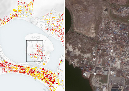
A photo of a satellite photographing the Florida state that suffered from Hurricane "Oma" that hit the US in September, and a photo analyzing the damage based on it. Photo by Digital Global Homepage
In the era of the Fourth Industrial Revolution, with the keywords of connection, convergence, and cooperation, the space industry is changing and innovating.
The center of gravity shifts to a software development paradigm that creates new added value by utilizing vast amount of data information pouring through hardware-centric development paradigms such as launch vehicles, satellites, and payloads.
In recent years, advanced ICT technologies such as AI, Big Data, cloud computing, etc., and space technology called ¡®a collection of technologies¡¯ are rapidly merging.
In particular, `satellite image utilization industry` utilizing satellite image information is getting attention as `Blue Ocean`.
¡Þ Satellite Video Utilization Industry Grows Rapidly = More than 1,500 satellites around the world are observing the earth as they travel through space. As the satellite launches centered on advanced countries in the space have joined the emerging nations to compete in unlimited competition, massive data and information are being produced every day by satellites operated by each country.
The visual information of Earth observation satellites is widely used in the public and private sectors such as national geography, marine and fisheries among them, agriculture and forestry, water resources, disaster and disaster, environment and weather, and national security. The global satellite video market is expected to grow at an average annual rate of 9.6% from USD 548 million in 2006 to USD 3 billion by 2020. However, Korea is relatively lacking in utilization capability, technology, and infrastructure such as satellite image analysis and processing. In 2014, the government set up a comprehensive plan for utilizing satellite information, systematically spread satellite information including satellite images, and started industrialization. We will also build and operate a satellite information integration platform, a key tool for opening and utilizing satellite information.
¡Þ US, China, Europe, and the state-led `satellite image utilization` Spur-of-the-world advanced nations are leading the ecosystem by actively creating demand for satellite image use in the public domain. Based on these ecosystems, we are developing civil satellite image utilization industry.
The United States has been pushing USD 7.3 billion into the `In Hands on Debut` program, a project supported by the National Geographic Information Agency (NGA) to commercialize satellite imagery. Currently, digital globe, a global satellite image information company, is in charge of business and opens satellite image data free of charge. Europe will launch the Copernicus Project from 2014 as the leading agency of the European Space Agency (ESA) to provide satellite imagery services for environmental protection, urban management, regional planning, agriculture, health, transportation and climate change to provide.
The Chinese government is also making great use of satellite imagery. Since 2009, `One Map` system has been built and utilized to manage large-scale data such as land, space, and geological environment across the country as an integrated system. It is divided into 22 provinces through the one map, and it is divided by regions to effectively measure and manage land resources, land information, and geological environment, and to use it for land management and urban planning.
An expert of the Korea Institute of Science and Technology Policy said, "Satellite image information is a field that can create new value by combining with artificial intelligence and big data technology." We developed algorithms for easy use of satellite images, if the ecosystem can be created, it will contribute to new markets and job creation in the space industry. "
* This article has been written with the support of Korea Press Foundation.
Daejeon=By Lee Joon Gee bongchu@
